Satellite Imagery & the Hurricane
There was once a day when a hurricane on the magnitude of Katrina wouldn't have been much of a disaster. People tended to be more spread out, communities were more self-sufficient, and reporting the subsequent issues would rely on sketches or glass-plate photographs.
Then comes the 21st Century. Thousands people could be dead and tens of thousands are displaced when mere fractions of these numbers would have been reported as little as a hundred years ago. The 24-hour news cycle brings the event into homes around the world without waiting for newspapers and with more impact than radio. In fact, the “new radio” is the mobile phone or the Web log as individuals make their plight known directly to the public. And satellite imagery is the whipped cream on the Jell-O.
- CNET News.com has satellite images of New Orleans before and after Hurricane Katrina.
- BBCNews makes a similar comparison.
- Digital Globe supplied the pictures to CNET and has a great gallery with more pictures.
- Newsweek has a cool and informative interactive feature.
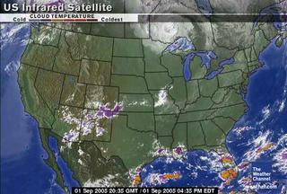
 Of course, the Weather Channel has excellent maps. Here's one that shows decreased temps in the affected areas. Radar images in motion are available, too, though it's not as interactive as I would like to see. And I'd like to have the ability to look at weather history maps. One day I'll get around to searching for an archive of such maps. Of course, one day Google will have them wrapped up with a ribbon and ready for us all to use. After all, they are famous for Google Earth and other mapping products now.
 And I do love Google Earth. Though it isn't usually as timely as images from other sources, updates are being put into place right now. Use this link if you have the program installed. It will add a location and interactive map for comparison before and after. Clever people, Google.
